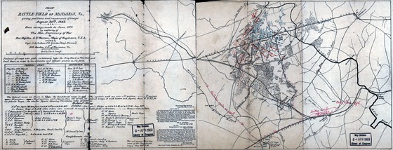
Map of battle-field of Manassas, Va., giving positions and movements of troops, August 30th, 1862; Creator, Warren, G. K.
Notes
- Scale 1:63,360.
- LC Civil War Maps (2nd ed.), 577.4
- “Positions of troops were given in testimony before the Army Board at West Point, and laid down on maps by the witnesses and officers present on the field.”
- “The Federal troops are shown in blue; the Confederate troops in red.”
- “The red arrows show the route of the Confederate troops, Aug. 30th, p.m.”
- Map has been annotated in red ink to show “Rickett’s route on 29th,” “Porter 9:20 a.m. 29th,” and “Porter’s corps 9:30 a.m. 29.”
Library of Congress map


